
![]()
![]()
![]()
![]()
![]()
![]()
![]()
![]()
![]()
![]()
![]()
![]()
![]()
![]()
Local news
- City Weekly
- Globe South
- Globe West
- North Weekly
-
NorthWest
Weekly
- New Hampshire
![]()

Local news
|
 |
|
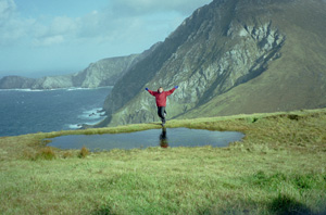
Achill Island's austere beauty looks across the ocean By Kari J. Bodnarchuk, Globe Correspondent,
3/17/2002 In most guidebooks, it rarely gets more than a one-page mention. I
never would have discovered this tucked-away spot, if not for Irish
friends who insisted I point my rental car west and make the four-hour,
cross-country drive from Dublin. ''It will be a grand time,'' one told me. ''The highlight of your trip, for sure,'' said another. They were right. After 10 days exploring Ireland, from Dublin to
Galway, and the Cliffs of Moher to the Connemara coast, I made my way to
County Mayo and headed west across the 113-year-old bridge. What I found
was a stunning, windswept region with crystal lakes, sheep-dotted valleys,
quartzite-capped mountains, and dramatic cliffs that rise up to 2,000 feet
above the sea. Achill (pronounced ACK-ill) measures 15 miles wide and 11 miles
from north to south and is shaped like an inverted L. Two-thirds of this
nearly treeless and largely uninhabited island is blanketed in peat bogs,
made of spongy moss and sundew; visit during March or April and you'll see
locals cutting peat from the bogs by machine or, occasionally, by hand.
Along the island's 80-mile coastline, there are five Blue
Flag beaches, an award and designation given to exceptionally pristine
beaches in Europe. Also hugging the coast are most of Achill's 3,500
residents, who live in 23 charming villages along the water or sprinkled
inland. Achill's remote location and exposure to the Atlantic Ocean's sometimes
harsh weather have not only shaped the island's physical beauty and
influenced human development, they have helped preserve its way of life.
Locals worry that more tourists may cause the island to lose some of that
character. For now, though, villages in Upper Achill are Gaeltacht -
Irish-speaking areas - and the pace across the island is invitingly
slow. Mobile banks visit the island several days a week (for 15-minute to
two-hour stops in different villages), and the mobile library rolls
through once a week. There's just one ATM, in Achill Sound, and ''it's
working very well now,'' according to one resident. Public e-mail service
is also now available, at the Crumpaun IT Centre in the village of Keel,
in a building that was once a local primary school. The list of outdoor pursuits available on Achill reads like a signup
sheet at the ultimate summer camp: surfing, swimming, windsurfing,
kayaking, canoeing, hiking, biking, rock climbing, rappelling, scuba
diving, and fishing. (Anglers can snatch brown trout from island lakes,
and blue shark and porbeagle from the sea.) Off-season, Achill is a sleepy, relaxed and, if the weather rolls in,
moody and beautifully dramatic place to be. You may have the hiking trails
and lodges virtually to yourself. Many activities are still doable;
windsurfers launch their sails year-round here (and host a national
competition every April), high walking trails (versus ones through
low-lying boggy areas) can still be traversed even in wet weather, and
many, though not all, restaurants and guesthouses remain open. Today, St. Patrick's Day, local pipe bands are marching through
villages in Dooagh, Pollagh, Keel, and Dookinella. But the island really comes alive in the summertime, with traditional
activities and annual events that include a nine-day Seafood Festival and
the Achill Yawl Sailing Festival in July, a music, dance, and language
event called Scoil Acla in August, plus two weeks of writing workshops and
an artists weekend. In fact, Achill has attracted notable artists for decades. Irish
painter Paul Henry spent eight years on the island during the 1950s,
American artist Robert Henri summered here in the 1920s, and German author
and Nobelist Heinrich Boll lived in Dugort village on and off during the
'60s and early '70s (in a house that, since 1992, has been used as a
residence for international and Irish artists and writers). Painters Charles Lamb and Derek Hill also drew inspiration from
Achill's stunning land- and seascapes. And Irish artist Desmond Turner
still owns a house on the island and has taught classes at his local
painting school for 35 summers now. One main road, the R319, cuts through the island from Achill Sound, the
first village you reach upon entering Achill, across open, rolling
bogland, and through the seaside villages of Keel and Dooagh, where Don
Allum, the first man to row across the Atlantic Ocean in both directions,
landed in 1987. If you continue along a narrow stretch of land to the
island's most outlying village, the road dead-ends at Keem, which has a
Blue Flag beach and is the jumping-off point for one of the island's most
spectacular hikes. If you can stomach the twisty, cliffside drive out to Keem, you can
handle this moderately difficult hike. The walk is flanked by cliffs and a
crumbling, old coast guard station on one side, and the Croaghaun Cliffs
(the tallest sea cliffs in Europe) and Croaghaun Mountain on the other
side. In between, you'll see peat bogs, sheep, and the stone ruins of a
house where Captain Charles Boycott lived when his servants shunned and
deserted him. Park in the small lot at Keem Bay and scramble up to Moyteoge Head,
then follow the undulating ridgeline along the cliffs to Achill Head,
which overlooks several rocky outcroppings. (Take care in windy, wet
conditions and be aware that fog and storms can roll in off the Atlantic
quickly.) There is a barely discernible path to follow, but you can easily
find your way in this totally open and exposed region. After dipping down
into the valley, climb Croaghaun Mountain and loop back around to Keem
Bay. The new book ''A Bilingual Guide to Walking in Achill'' outlines 14
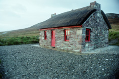
circular walks on the island. Bicyclists and motorists can navigate one of the most stunning routes
on Ireland's West Coast: Atlantic Drive, found at the southeastern tip of
the island. On this drive, you'll pass sheer cliffs, sprawling landscapes
with bogs, rocks, and, in one spot, a lone thatched house, plus gorgeous
seaside homes, several B&Bs, and views across the bay to Connemara's
rolling coastline. There are also promontory forts dating to the Iron Age,
the old Kildownet Castle, and a graveyard with memorials commemorating the
Clew Bay Drowning of 32 men in a boat en route to Scotland in 1894. Atlantic Drive officially ends at Ashleam, but you can continue along
the road past Dooega and Mweelin, then take an access road up Minaun
Mountain for sweeping views of the surrounding moorland, cliffs, ocean,
and villages, as well as the windy road you just drove. The area around
Mweelin, which has peat bogs measuring up to 20 feet deep, was covered in
pine forest during the Bronze Age, but all that's visible of it now are
stumps. Kari J. Bodnarchuk is a freelance writer who lives in
Somerville. This story ran on page M1 of the Boston Globe on
3/17/2002.
Back to previous page, Globe articles |
|
© Copyright 2002
Boston Globe Electronic Publishing Inc. | |||||||||
 E-mail will most likely be the last thing on your mind when you visit,
though. In any season, there is enough to keep you busy for days on end:
Explore Atlantic Drive, one of the most scenic roads in Ireland, sip
Guinness in a local pub, cozy up to a turf fire, or get out and explore
the area on foot, bike, kayak, or anyway you like.
E-mail will most likely be the last thing on your mind when you visit,
though. In any season, there is enough to keep you busy for days on end:
Explore Atlantic Drive, one of the most scenic roads in Ireland, sip
Guinness in a local pub, cozy up to a turf fire, or get out and explore
the area on foot, bike, kayak, or anyway you like.
